Project Two: Porto Taxi Trip Visualization System
|
System Goal:
Provide an online visualization tools for researchers and practitioners to understand the real-world mobility data of taxi trajectories. Taxi trajectory is the recording of the positions of a taxi at specific space-time domain, for a given taxi and a given time interval, it is presented as a sequence of geometric location in 2D spatial system (xi, yi, ti). This system provides a set of interactive functions for users to explore the information of taxi trips.
In order to make an open source software for domain users, we are sincerely seeking feedback and suggestions to improve our system. We welcome you to use of demo systems, and provide us your valuable input at system evaluation. Your time and efforts are greatly appreciated.
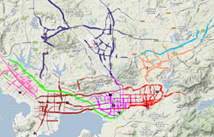
Dataset:
The dataset used in this system is the trajectory data of taxi trips. It is collected by taxi cabs in Porto City in Portugal from (07,2013) to (06,2014). The total number of trajectories is 1700000. Each taxi trajectory consists of the following attributes: Car ID, Trip ID, Pickup time, Dropoff time, Trip time in secs, Trip distance in miles, Pickup and Dropoff location (longitude, latitude), and trip trajectory.
System Functions:
The system supports users with interactive query and visualization functions:
- Data Query Functions:
- Region selection: select interested regions from the map for trajectories starting, ending or passing. The spatial constrains can be done in single or multiple selection regions;
- Time selection: select time intervals associated with the region selection.
- Visualization functions: After query, the system visualizes the query results:
- Trajectories combined with pick-up and drop-off locations are shown on the map. The users can change the display mode from raw to heat map or welded graph to show the spatial density of such locations.
- Visual charts/diagrams are shown in visual reports to show the statistics of the result trajectories. Table view is also provided in visual reports. The Users can choose single or multiple trajectories to show them on the map and study their behaviors.
System use:
A tutorial video demonstrating the system is available here.
Click here to enter the online visualization system
System Evaluation:
Please follow this link and kindly answer the questions and provide your comments and suggestions. Your time and efforts are greatly appreciated!