Project Goal and Design:
GeoVisuals project aims to create software and data repository that advance field studies of worldwide researchers, practitioners, and educators.
The tasks are to support users to:
- Capture and transfer geospatial multimedia data in a variety of different field settings ranging from developed countries with advanced IT infrastructures, to countries that still lack a reliable access to the Internet.
- Manage and explore the collected data for easy merging and query of GPS, video, audio, narratives, and so on - with flexibility for multiple input types.
- Apply qualitative, quantitative, and spatial data analysis with visual representations and interactions.
Meanwhile, the GeoVisuals Data Repository allows field researchers to share their own data and access the analytical and visualization functions through a web-based platform.
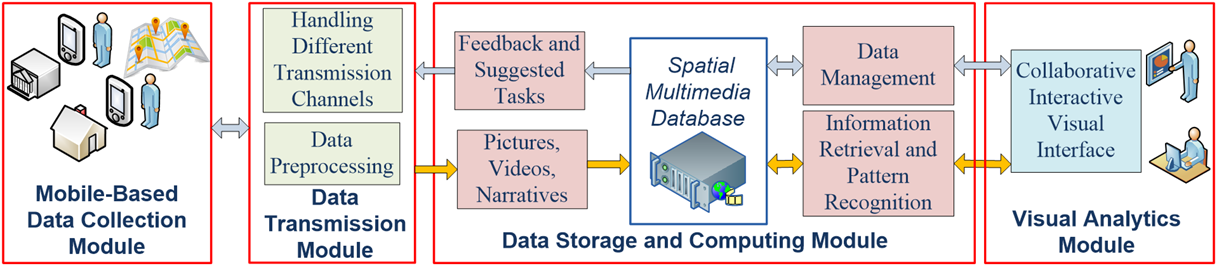
System Framework
The framework consists of a mobile data collection module, a data transmission module, a data storage and computing module, and a visual analytics module. They can help users conduct the following work:
- Mobile Data Collection: A mobile APP help workers or volunteers to acquire live situations surrounding them as videos, photos and narratives linked to GPS locations.
- Data Transmission and Frontend Preprocessing: Tools that can transmit the collected data to server-side database through WiFi/Mobile or direct connections. The video and audio data is processed to retrieve images, texts, and link them to geographical coordinates.
- Spatial Multimedia Database: A spatial database receives and manages massive multimedia data over spatial-temporal dimensions. Various spatial/temporal/semantic queries are fulfilled in real time by specifically designed database techniques actions. The GeoVisuals Data Repository is be implemented through Web server service.
- Visual Analytics of Geospatial Multimedia Data: A Web-based interface provides visualization functions for users to filter, observe and analyze the spatial data of videos, photos and narratives. Users can perform progressive visual exploration, hypothesis generation and evaluation with real-time interactive visualization.